On our August 2011 trip to Quetico, Cristin and I sought out and found the
Cache Bay pictographs, located a bit off the beaten path in a dead-end bay on the west side of Cache Bay. Please see the companion blog "
Quetico" for more on our whirlwind Quetico trip.
See also a description of our epic snowshoe hike in January 2011 to the Hegman Lake Pictographs in the BWCA.
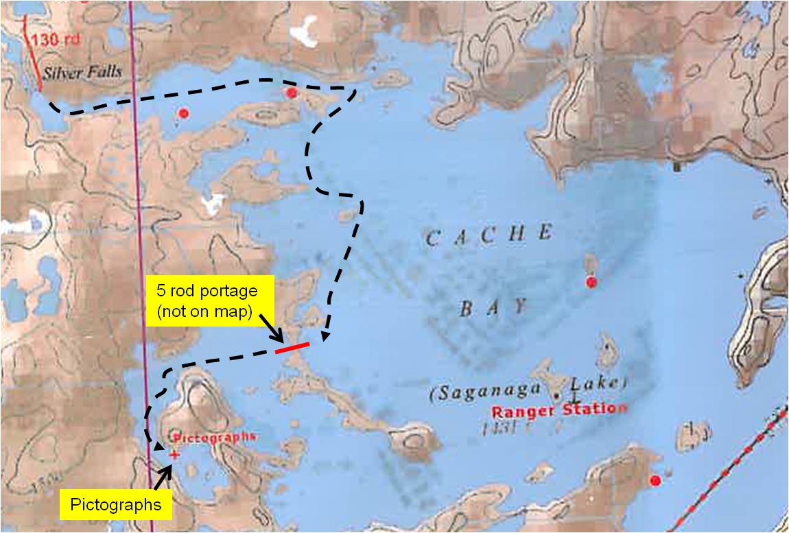
The pictographs are noted on the McKenzie Map (6-A Saganagons) but for some reason local experts like our outfitter and the Quetico Range Gal stationed at the Cache Bay seemed to think additional details were needed to find them, so they both marked up our maps on the 1st day of our trip. Ranger Gal particularly elaborated with great detail on the location and position and mentioned how some parties never find them.
On the morning of Day 3 of our Quetico trip, our last day, we departed our campsite on Lake Saganagons with the ultimate destination of Hook Island, where we had arranged a 3PM canoe shuttle with our outfitter. We planned a quick side trip to the pictographs, having just a enough time and perfect weather conditions.
 |
Our route on Cache Bay to Pictographs
CLICK TO ENLARGE | | | | | |
|
|
|
|
Both the outfitter and Ranger Gal had suggested using an unmarked and very short portage into the western most bay of Cache Bay. We followed Janice's suggestion of leaving our packs at the portage and coming back that way, although the map indicates we did have the option after seeing the pictographs to paddle thru to the main part of Cache Bay in the direction we were heading without the need to portage.
 |
Google Earth map of the area of the pictographs.
The water appears greyish-white due to the angle of the sun reflecting off
the water surface relative to the camera lens.
CLICK TO ENLARGE | | | | | |
|
|
When we began searching for the pictographs, we somehow misunderstood the additional instructions and were expecting to see the pictographs well north of where they actually exist, as marked by the blue line on the map above. The shoreline in this area is rocky but there are no steep cliffs. We were also led to believe that the pictographs were very hard to spot and high up from the water. In reality, the pictographs are on steep cliffs that plunge into the water and not that far above the surface of the water, a few feet at most. The one clue that we found helpful is that the pictographs are on rock face that is angled away from the primary cliff face orientation when approaching from the north, so you can't see them until you are almost directly in front of them. In short, look for the sheer cliff on this shoreline and you will find them easily!
 |
| Ecstatic to have found the pictographs! |
We paddled slowly back and forth in the area north of the pictographs (blue line on map), searching fruitlessly, and we were about to give up when Cristin asked if we could make one more pass, feeling pressure from me to abort our search so we would not be late for our shuttle. I consented and then she suggested looking at the cliff area just to the south where we hit pay dirt!
We were very pleased to have found the pictographs! We left almost as quickly as we arrived and made our canoe shuttle at Hook Island with 15 minutes to spare.
That evening as we settled into our fancy hotel on Lake Superior in Canal Park in Duluth (I was beginning a week long training course for work), it was fun to reflect on our whirlwind day, starting from our campsite on Lake Saganagons, the dead calm conditions on the lakes, the successful search for the pictographs, paddling to Hook Island, our shuttle back to the outfitter, the drive on the Gunflint Trail (saw a moose), dinner in Grand Marais, and a finally Duluth. A memorably whirlwind day!


No comments:
Post a Comment